Hurricane Florence
Days after making landfall as a hurricane and slowing to a tropical depression, Florence slowly ravaged the South with rain and wind, leaving widespread and potentially catastrophic flooding.
IF YOU WANT TO HELP:
Financial Contributions:
Florence Recovery Fund:
United Way created the United Way Hurricane Florence Recovery Fund to support local communities in South Carolina, North Carolina, Virginia and the surrounding areas affected by Hurricane Florence. This fund will help local United Ways meet the storm-related needs and support mid- and long-term recovery efforts throughout the affected regions. 100% of individual donations given to the United Way Hurricane Florence Recovery Fund will be distributed to local United Ways in the affected areas. United Way’s focus will be on mid- and long-term recovery.
Donated Goods:
United Way of Long Island is not collecting or transporting donated goods to the affected areas.
FEMA Recommends: It is better to send cash donations instead of having to transport and store items at great expense. Quite often, survivors do not need or can’t use goods that are donated by generous fellow citizens. Organizations that receive unsolicited donations have to take time to catalogue and store such materials, which takes valuable time away from working on urgent needs.
Volunteer/Resources:
To connect to national organizations seeking volunteers: National Voluntary Organizations Active in Disaster (NVOAD), www.nvoad.org
IF YOU NEED HELP:
2-1-1 across all affected areas is operational. If someone you know needs help, they can call 2-1-1, 24 hours a day, seven days a week. There may be a wait, but calls will be answered. In case of emergency, dial 9-1-1.
2-1-1 is a free, confidential service that connects people from all communities to essential health and human services—24 hours a day, seven days a week. 2-1-1 will remain open and ready to provide local information about evacuation routes, shelters, food and water, health resources, and other needs throughout the storm.
North Carolina 211 2-1-1 or 1-888-892-1162 www.nc211.org
211 South Carolina 2-1-1 or 1-866-892-9211 www.sc211.org
211 Virginia 2-1-1 or 1-800-230-6977 www.211virginia.org
Below is a list of standard resources in the states expected to be impacted by Hurricane Florence. Each resource will likely be continually updated as more information and resources become available. Each state has active 2-1-1 Call Centers and Databases that can be accessed. In the event a 2-1-1 center must evacuate, back-up will be provided by 2-1-1s around the country.
Text FLORENCE to 898-211
The 898-211 text platform has been activated to provide automated responses containing pertinent disaster information to individuals. After texting “Florence” to 898-211, clients will automatically be sent resources for their state (North Carolina, South Carolina, Virginia, Georgia, and Other).
If a client texts their zip code to 898-211, their message will go to the local 2-1-1’s text queue, if a texting platform is in use there.
General
-Hurricane Preparedness: https://www.ready.gov/hurricanes
-Shelter Locations: https://www.redcross.org/get-help/disaster-relief-and-recovery-services/find-an-open-shelter.html
-Airbnb Open Homes (Airbnb hosts open homes to evacuees for free): https://www.airbnb.com/welcome/evacuees/hurricane-florence-2018
North Carolina
-North Carolina 2-1-1 Disaster Resources: https://www.nc211.org/
-Updates from the State of North Carolina, including evacuation orders: https://www.ncdps.gov/florence
-Download the Ready NC Mobile Application: https://readync.org/EN/DOWNLOADAPP.html
South Carolina
-South Carolina 2-1-1 Disaster Resources: http://www.sc211.org/index.php/disaster
-Updates from the State of South Carolina, including evacuation orders: https://scemd.org/
-Download the SC Emergency Manager Mobile Application: https://www.scemd.org/stay-informed/mobile-applications/
Virginia
-Virginia 2-1-1 Resources: https://www.211virginia.org
-Updates from the Virginia Department of Emergency Management: https://twitter.com/vdem
Georgia
-NE Georgia 2-1-1 Resources: http://www.unitedwaynega.org/get-help-2-1-1-program
-Georgia Emergency Management & Homeland Security Agency Updates: http://www.gema.ga.gov/
Winter Storm Toby
PSEG Long Island has restored service to 5,200 customers resulting from this storm. For those without power, do not run any gas powered engines, including generators, in a garage or other enclosed space. Do not use your oven to heat your home.
Suffolk County Transit is operating but customers should expect delays. Customers can call 631.852.5200 for updates on bus locations and trip planing information.
NICE Bus is operating with system wide suspensions and delays. Check http://nicebus.com/Passenger-Information/Service-Alerts.aspx for updates.
For important phone numbers and contact information for Recovery, visit the Resources page
March 21
The National Weather Service is predicting 10-18″ for much of Long Island, throughout today and overnight, with strong wind gusts and minor to moderate coastal flooding.
Preparedness tips for winter storms
Suffolk County Transit will not be operating on Wednesday March 21
For updates on NICE Bus, visit http://nicebus.com/Passenger-Information/Service-Alerts.aspx
For updates on Long Island Rail Road service, visit www.mta.info/lirr
If you need additional information and referral, call United Way’s 2-1-1 Long Island helpline 24/7 at 2-1-1 or 1.888.774.7633
March 20
PSEG Long Island Information:
- To report and receive status updates on an outage Text OUT to PSEGLI (773454) or to report an outage online visit psegliny.com
- Follow PSEG Long Island on Facebook and Twitter to report an outage and to get updates before, during and after the storm
- Downed wires should always be considered “live.” Do not approach or drive over a downed line and do not touch anything contacting the wire. To report a downed wire call PSEG Long Island’s 24-hour Electric Service number: 1-800-490-0075
- Visit PSEG Long Island’s outage map to view outage information across Long Island and the Rockaways at https://outagemap.psegliny.com/
NASSAU COUNTY:
The Nassau County Winter Homeless Hotline – 1-866-WARMBED – is open and runs seven days a week through March 31st, 2018. Between the hours of 6:00 p.m. and 8:00 a.m. Monday thru Thursday, and Friday from 6:00 p.m. thru Monday at 8:00 a.m., employees from the Department of Social Services (DSS) will make appropriate referrals and provide shelter placement. Between 8:00 a.m. and 4:00 p.m., Monday – Friday, call the Department of Social Services at (516) 227-8519. Nassau County Department of Social Services after office hours 516-573-8626.
SUFFOLK COUNTY:
If you are homeless and in need of shelter –call the Suffolk County Department of Social Services Temporary Housing Assistance Unit from 8 a.m. – 4 p.m., Monday to Friday at 631-854-9547 or go to the nearest Suffolk County Department of Social Services (DSS), as early as possible, between the hours of 8:00 a.m. – 3:00 p.m. If a person experiences a housing crisis after 4:30 p.m. during the week, anytime during the weekend, or during a Holiday, call the DSS Emergency Services Unit at 631-845-9100.
Riverhead DSS Center (631) 852-3500
Coram DSS Center (631) 854-2300
Smithtown DSS Center (631) 853-8714
South West DSS Center (Deer Park) (631) 854-6600
March 7 Nor’Easter Storm Updates
PSEG Long Island announced that power restoration from the March 7 nor’easter was completed on Saturday March 10. The storm affected 91,734 customers, all were returned to service on Saturday.
March 9
Winter Storm Quinn has passed through our area, and recovery efforts are currently underway.
PSEG Long Island updates
- PSEG Long Island is reporting about 13,148 of its approximately 1.1 million customers across Long Island and the Rockaways are currently without service.
- As of 4pm, the utility has restored service to 75,846 of the 89,456 customers affected by Wednesday’s nor’easter
- To report downed wires or power outages, customers should call PSEG Long Island’s Electric Service line at 1-800-490-0075
- Utilize MyAlerts, PSEG Long Island’s text message service. Once registered, report power outages by texting “OUT” to PSEGLI (773454)
- To register have your account number available and text REG to PSEGLI (773454)
- Check for updates using the outage map at https://outagemap.psegliny.com/
- To prevent carbon monoxide poisoning, do not run any gasoline powered engines, including generators, in a garage or any other enclosed space. Do not use your oven to heat your home.
Resources
Real-time traffic closures on a map: https://www.511ny.org/#TransitRegion-8
Long Island Railroad Service Alerts: http://www.mta.info/lirr
NICE Bus Service Alerts: http://nicebus.com/Passenger-Information/Service-Alerts.aspx
Suffolk County Transit Service Alerts: http://sct-bus.org/
NASSAU COUNTY:
The Nassau County Winter Homeless Hotline – 1-866-WARMBED – is open and runs seven days a week through March 31st, 2018. Between the hours of 6:00 p.m. and 8:00 a.m. Monday thru Thursday, and Friday from 6:00 p.m. thru Monday at 8:00 a.m., employees from the Department of Social Services (DSS) will make appropriate referrals and provide shelter placement. Between 8:00 a.m. and 4:00 p.m., Monday – Friday, call the Department of Social Services at (516) 227-8519. Nassau County Department of Social Services after office hours 516-573-8626.
SUFFOLK COUNTY:
If you are homeless and in need of shelter –call the Suffolk County Department of Social Services Temporary Housing Assistance Unit from 8 a.m. – 4 p.m., Monday to Friday at 631-854-9547 or go to the nearest Suffolk County Department of Social Services (DSS), as early as possible, between the hours of 8:00 a.m. – 3:00 p.m. If a person experiences a housing crisis after 4:30 p.m. during the week, anytime during the weekend, or during a Holiday, call the DSS Emergency Services Unit at 631-845-9100.
Riverhead DSS Center (631) 852-3500
Coram DSS Center (631) 854-2300
Smithtown DSS Center (631) 853-8714
South West DSS Center (Deer Park) (631) 854-6600
March 7
The National Weather Service has issued the following advisories in regards to the Nor’easter approaching the Long Island area:
Winter Storm Warnings and Winter Weather Advisories remain in effect across the majority of the region until 4am Thursday March 8. Plan on difficult travel conditions, including during the evening commute. Tree branches could fall. Be prepared for significant reductions in visibility at times.
How to prepare for winter storms
How to prepare for floods
Winter Storm Grayson
A wind chill advisory is currently in effect until 10am Saturday, with wind gusts of 35-45mph expected. These bitter winds could cause frostbite in as little as 30 minutes to any exposed skin. Take precaution when going outside.
Long Island school districts remain closed for the second day. For specific town information, visit local websites which can be found in Recovery Resources.
Report power outages to PSEG Long Island at 800-490-0075 or text OUT to PSEGLI. Follow @PSEGLI on Facebook and Twitter to report an outage and for updates before, during and after the storm.
Long Island Railroad is running with scattered delays and schedule changes. Visit http://lirr42.mta.info for up to date information
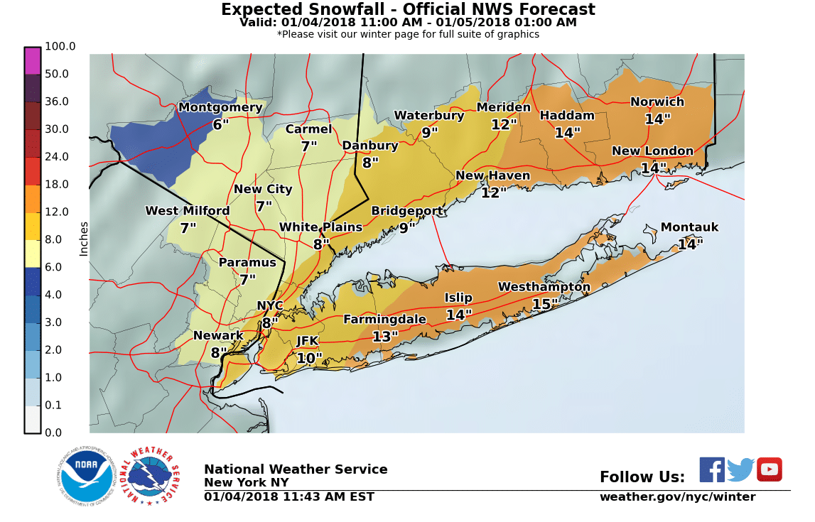
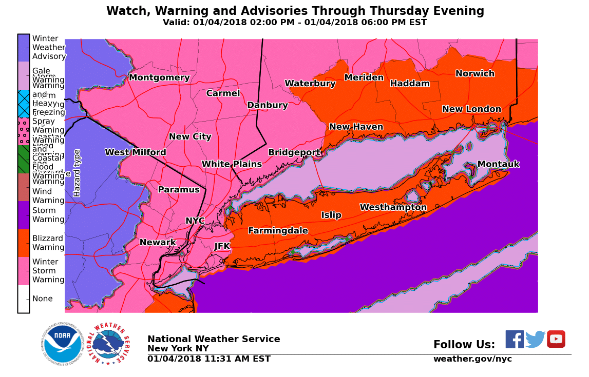
January 4
Governor Andrew Cuomo declared a state of emergency for Long Island as Winter Storm Grayson hit our region on Thursday.
Nassau and Suffolk Counties are under a blizzard warning until 1am on Friday, with high winds and snow accumulations of up to a foot are expected. Conditions are expected to continue until 5-6pm, then should taper off.
Tips on how to stay safe before, during and after a winter storm.
Local alerts and conditions
Report power outages to PSEG Long Island at 800-490-0075 or text OUT to PSEGLI. Follow @PSEGLI on Facebook and Twitter to report an outage and for updates before, during and after the storm.
There are delays and cancelations systemwide on the Long Island Railroad.
Visit http://lirr42.mta.info for up to date information
Many flights are cancelled out of LI MacArthur Airport, Kennedy and LaGuardia. Check with your airline for updates.
Town Information
Town Huntington- all activities cancelled; limited town hall service call 641-351-3234. HART Bus and paratransit cancelled.
Town Islip- senior and recreation programs closed.
Town Brookhaven- senior and recreation centers closed. Call 631-415-TOWN with storm issues.
Town East Hampton- Town Hall and all offices closed.
Town Southampton- all town facilities closed.
Town Southold- all town facilities closed. Southold Emergency Management opened shelters at Peconic Community Center at 1170 Peconic Lane, Peconic and Human Resource Center at 750 Pacific St, Mattituck for special needs non-medical persons.
Town Shelter Island- all town offices closed.
Town Hempstead- bus service to senior centers & shopping cancelled.
Town North Hempstead- town transportation cancelled
Town Oyster Bay- senior centers closed and some youth & community services cancelled- check oysterbay.com
City Long Beach- paratransit cancelled, bus service suspended until 4pm; Atlantic Beach Bridge closure on 1/5/18 has been cancelled.
For additional assistance, or for detailed information on local programs and services, dial 2-1-1 or 888-774-7633 to speak with a call center specialist. Information is also available at www.211longisland.org
Tropical Storm Nate
Nate first struck near the mouth of the Mississippi River on the southeastern Louisiana coast as a Category 1 storm Saturday night and again near Biloxi, Miss., early Sunday morning knocking out power for more than 100,000 customers across the region and causing scattered flooding, but it was not as devastating as they expected and quickly lost force as it moved inland.
After several hours of heavy rainfall, the National Hurricane Center downgraded the tropical storm to a tropical depression and has subsequently discontinued all hurricane and storm surge warnings and watches.
At 2:15 a.m. local time Sunday, the National Weather Service of Mobile measured water surges of 5.6 to 5.7 feet at locations near the city.
The National Hurricane Center said Nate will “quickly weaken as it moves farther inland” and “should degenerate into a remnant low late Monday.”
The Long Island region should expect to see bouts of heavy rain and winds as the remnants of the storm passes through the area.
Hurricane Jose
The Tropical Storm Watch was discontinued for Suffolk County. Swells generated by the storm will continue to affect the shores, causing dangerous surf and rip current conditions for the next several days. Eastern Long Island is expected to experience gusty winds throughout the day, as the storm moves east conditions will improve.
September 19
The Tropical Storm Watch was discontinued for Nassau County. Hurricane Jose will pass southeast of the area late Tuesday night into Wednesday as a tropical storm. Tropical Storm Watch Remains in effect for Suffolk County, especially Eastern Long Island where tropical storm conditions are likely with sustained winds of 30 to 40 mph and gusts up to 50 mph, heavy rain bands Tuesday night into Wednesday with 1 to 3 inches possible and localized flash flooding possible in the typically more vulnerable locations along the south shore back bays of Long Island.
September 18
While the center of Jose is forecast to remain offshore, the cyclone could cause some direct impacts from Delaware to New England. A Tropical Storm watch is now in effect for Long Island, and minor to moderate coastal flooding is possible over the next several days. Swells from the storm are likely to cause dangerous surf and rip current conditions – it is best to remain out of the water.
Heavy rain is anticipated as Jose passes near Long Island on Tuesday and Wednesday, total accumulations of 3-5 inches are expected over eastern Long Island.
It is best to take preparedness measures before Jose reaches our area.
To sign up to receive alerts for your area, visit the Resources page.
Stay up to date with PSEG Long Island’s Storm Center.
Track Jose’s path
Hurricane Irma
PSEG Long Island crews have restored power to thousands of Florida customers. The utility sent more than 460 PSEG Long Island employees and contractors to assist Florida Power & Light, Tampa Electric Company and Duke Energy (Florida) following Hurricane Irma. Read more.
If you want to help:
Financial Donations:
United Way’s Irma Recovery Fund: www.unitedway.org/hurricane-irma
This fund will help local United Ways meet the storm-related needs and support long-term recovery throughout the affected regions. With your support, we can help rebuild communities. 100% of individual donations given to the United Way Irma Recovery Fund will be distributed to local United Ways in the affected areas.
September 15
As Irma stormed through Florida, the area most affected by its destruction was the Florida Keys. It is reported that 25% of all homes in the Keys were destroyed, with 65% sustaining major damage. There are still hundreds of thousands in South Florida who do not have power.
Learn more about how BeReadyLI partner PSEG Long Island is helping those affected.
September 11
As of 11am on Monday, Irma is now a tropical storm and has sustained winds of 65 mph was moving north-northwest about 70 miles east of Tallahassee, Florida. Forecasters expect the storm to stay inland over Florida as it heads to Georgia, before moving on to Alabama and Tennessee. The National Weather service reported that flooding from a storm surge in Jacksonville had exceeded a record set by Hurricane Dora in 1965. Approximately 5.8 million customers are without power across Florida.
September 10
After leaving catastrophic damage in the Caribbean, Hurricane Irma slammed into the U.S. – hitting the Florida Keys first and then it made a second landfall in Marco Island. Flooding, downed power lines and toppled trees are just some of the dangers that lie ahead.
Hurricane Irma continues its path up the coast, now a Category 2 storm, threatening to bring dangerous storm surges along Florida’s west coast, the National Hurricane Center said Sunday evening. At 5 p.m. ET, the storm was about 5 miles north of Naples, Florida, packing maximum sustained winds of 110 mph.
September 6
Hurricane Irma quickly become one of the most powerful Atlantic Ocean hurricanes recorded, with wind speeds of 185 miles per hour at its height. The hurricane – which went from a Category 5 to a Category 4 – has passed through the Caribbean, Haiti and Turks and Caicos and will continue to bring wind, storm surge and rainfall to the Bahamas, as well as portions of Cuba and Cuban Keys through Saturday.
Irma is likely to make landfall in Florida as a dangerous major hurricane, and will bring threatening wind to much of the state regardless of the exact track of the center. Hundreds of thousands of people in the state have evacuated and millions of others have been told to be ready to leave their homes.
We will continue to post updates on this storm, and how you can help.
Hurricane Harvey
If you want to help:
Financial Donations:
United Way’s Harvey Recovery Fund: www.unitedway.org/Harvey
This fund will help local United Ways meet the storm-related needs and support long-term recovery throughout the affected regions. With your support, we can help rebuild communities. 100% of individual donations given to the United Way Harvey Recovery Fund will be distributed to local United Ways in the affected areas.
Volunteer/Resources:
Health & Welfare Council of Long Island’s Hurricane Harvey- How to Help Resource
To connect to national organizations seeking volunteers: National Voluntary Organizations Active in Disaster (NVOAD), www.nvoad.org
Food/Supplies:
The Smithtown Fire Department is accepting supplies to send down on a semi-tractor trailer next week. Donations can be delivered to their Main House at 100 Elm Avenue, Smithtown from 12-3pm and 6-9pm until September 6. Current needs include, cleaning supplies and tubs/buckets, new or gently used car seats, strollers, pack and plays, new children and adult undergarments and hygiene products.
Island Harvest Supply Collection Sites are accepting human and pet supplies, open between 9am-5pm weekdays:
– Island Harvest Food Bank, 15 Gumman Road West, Suite 1450 Bethpage
– Hauppauge Distribution Center, 40 Marcus Blvd., Hauppauge
– Uniondale Distribution Center, 875 Jerusalem Ave.m Uniondale (at the A. Holly Patterson Extended Care Facility)
– Christopher Morley Park Administration Building (10am-6pm), 500 Searingtown Rd., Roslyn
– Eisenhower Park Golf/Driving Range (10am-8pm), 1899 Park Blvd., East Meadow
– Cedar Creek Park Administration Building (10am-6pm), 3340 Merrick Rd., Seaford
– Grant Park Administration Building (10am-6pm), 1625 Broadway, Hewlett
On Tuesday, September 5, The Village of Hempstead is partnering with the The Salvation Army for HEMPSTEAD GIVES DAY. Drop off non-perishable goods or new/gently used clothing a the following locations between the hours of 8:30am to 4:15pm:
– Village Hall, 99 Nichols Court, Hempstead
– Kennedy Memorial Park, 335 Greenwhich Street, Hempstead
– Brierley Park, 65 Dartmouth Street, Hempstead
If you need help:
Hurricane Harvey map – View information related to the storm including public alerts, evacuation resources and shelters, traffic and transit and precipitation.
2-1-1 across all affected areas is operational. If someone you know needs help, they can call 2-1-1, 24 hours a day, seven days a week. There may be a wait, but calls will be answered. In case of emergency, dial 9-1-1.
2-1-1 is a free, confidential service that connects people from all communities to essential health and human services—24 hours a day, seven days a week. 2-1-1 will remain open and ready to provide local information about evacuation routes, shelters, food and water, health resources, and other needs throughout the storm.
September 1
Today marks the first day of National Preparedness Month, a reminder of the importance of being ready for any type of emergency. Updates have been made to how you can help the victims of Hurricane Harvey in both the short and long-term recovery efforts.
August 31
The storm was downgraded to a tropical depression on Wednesday night. It is expected to move through northeastern Louisiana and northwestern Mississippi through Thursday.
United Way has created the Harvey Recovery Fund to support local communities in Texas, Louisiana and the surrounding areas affected by Hurricane Harvey. 100 percent of individual donations given to the United Way Harvey Recovery Fund will be distributed to local United Ways in those areas. The Leonardo DiCaprio Foundation pledged $1 million as the inaugural donation to this fund.
August 30
The storm made its second landfall just west of Cameron, Louisiana early morning on Wednesday. Below, you can find ways to help those affected by Hurricane Harvey.
Friday marks the first day of National Preparedness Month, further highlighting the importance of having a family plan and being ready before a disaster strikes. Learn more about how you can be prepared and stay safe with our Preparedness Resources.
August 29
Tropical Storm Harvey strengthened into a hurricane over the Gulf of Mexico last week and made landfall northeast of Corpus Christi, Texas, around 9:45 p.m. on Friday. It was a Category 4 hurricane with winds of 130 miles per hour. It then moved offshore before making landfall again on the shore of Copano Bay, this time as a Category 3 hurricane. The affected area includes some of Texas’ most populous cities, stretching along the state’s Gulf Coast from Corpus Christi to Houston, and inland to Austin and San Antonio. Forecasters say that by the time the storm ends, some areas may see more than 50 inches of rain.
The largest of its kind to make landfall in the United States since 2005, Hurricane Harvey is leaving a wake of destruction in its path—but there is hope. Please join us in keeping these communities in your thoughts as the situation evolves. The road ahead for these communities is long and the network of United Ways all over the world is here to help.
Nassau County Flash Flood Watch
A Flash Flood Watch has been issued for Nassau County from June 19, 12:00 noon until June 20, 4:00 am . A Severe Thunderstorm Watch in effect for Nassau County from June 19, 11:15 am until 8:00 pm. Scattered storms could produce damaging wind gusts of 60+ mph, possible hail and lightening. There is a very low chance of isolated weak tornadoes. Across all of Long Island there is a threat of locally heavy rains, with the heaviest rains toward western regions. There is also a high risk of rip currents Nassau County and Southwestern Suffolk County beaches from 12:00 noon through late tonight, meaning dangerous and potentially life threatening conditions exist for all people entering the surf.
Wind and Flood Warning – January 23
Tuesday Jan 24
Residual minor Coastal Flooding expected for Southern Nassau County into early afternoon.
Monday Jan 23
Winds are expected to reach 30-40mph with gusts up to 60mph, with the strongest wins expected in the afternoon into this evening. These winds will blow down trees and power lines, making travel difficult.
The Coastal Flood Warning remains in effect along the South Shore of Long Island during high tide. Residents should take all necessary precautions to protect their homes against rising water levels.
Sunday Jan 22
The National Weather Service has issued a High Wind Warning for Nassau and Suffolk Counties in effect from 1am Monday to 1am Tuesday the 24th.
Winds could reach 30-40mph with gusts reaching 60-70mph, with the strongest winds expected Monday afternoon and evening.
There is also a Coastal Flood Warning along the South Shore of Long Island for Monday evening.